Mulholland Drive
Photograph: Michael Juliano

The 7 best scenic drives in L.A.

See the most beautiful vistas in L.A. from your car window with these scenic drives, from Mulholland to the mountains

Michael Juliano
Advertising

While commuting is a ceaseless source of frustration, a scenic drive can also be one of the most freeing and picturesque things to do in L.A. I know that I’ve certainly stared up at the palm trees along Sunset Boulevard or the Art Deco buildings on Wilshire Boulevard and taken a second to appreciate just how lovely L.A. can look at street level.

These scenic drives below—through mountain ranges and along beaches in L.A.—flaunt more than just run-of-the-mill flora and architecture. These are the sort of drives that are worth wandering a few miles out of the for; in particular when I have out-of-town friends visiting, these routes are pretty easy-to-plan ways to impress first-timers and repeat visitors alike. So fill up the tank or charge up the car, wait out rush hour and start planning to pilot your way through these seven scenic drives in Los Angeles.

Looking to tack on a few extra miles to your drive? Try one of these day trips from L.A.

Most scenic drives in Los Angeles

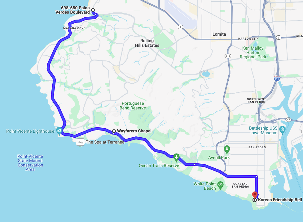
Palos Verdes Drive around the Palos Verdes Peninsula

As South Bay beaches give way to golden-hued bluffs you’ll encounter more than 10 miles of streets hugging the coast from the Torrance border to San Pedro. Start the drive with a dramatic clifftop view toward the Santa Monica Mountains from a small parking lot at the intersection of Paseo del Mar and Palos Verdes Drive in Palos Verdes Estates.

The first third of the drive sticks mostly to spectacular real estate a few blocks inland, but after you round Point Vicente, the drive changes dramatically. For a few miles past Terranea, there’s nothing but undeveloped oceanfront hillsides and winding roads, as well as the former site of Wayfarers Chapel, which was dismantled due to rapid land movement in PV (so, you know, maybe tackle this route sooner rather than later).

Once you enter San Pedro, the drive turns more residential and industrial, but I happen to think there’s something visually arresting about that first glimpse of the Port of L.A. Consider wrapping up at the Korean Bell of Friendship for a more idyllic terminus.

14 miles; 30 minutes

Malibu Canyon to PCH

When the small blue sign on Las Virgenes Road announces “scenic route begin,” it isn’t kidding; a cluster of housing developments immediately give way to stunning views of the Santa Monica Mountains. As you pass Malibu Creek State Park and Malibu Temple, you’ll slice your way through the isolated canyons. Follow the smell of ocean air to Pepperdine’s lush lawn—look out for lounging deer—where you’ll make a right onto the Pacific Coast Highway.

(It’s worth mentioning that Malibu Canyon Road sits just outside of the western edge of the Palisades Fire burn area; you may notice some charred hillsides to the east, but the ride is otherwise undisturbed. However, rockslides are always an ongoing concern along the rugged road, so do double check any road closures before you embark.)

The rest of the drive along PCH features glittery ocean views as the lush coastal mountains meet the turquoise shore. Though you could chart a course for the distant Point Mugu cape, the drive turns less dramatic—though more remote—once you pass the county line. I recommended wrapping up at Point Dume instead (perhaps my favorite beach in the entire county), or a little farther up the coast at El Matador or Neptune’s Net.

As an alternative route in, Kanan Dume Road climbs past ranches and through hillsides with green mountainous vistas. It’ll dump you out right near Point Dume, so it also means missing a considerable portion of the eastern coastline drive. Consider taking one of these two canyon roads into Malibu and the other out on your way home.

24 miles; 35 minutes

Advertising

Angeles Crest Highway to Mt. Wilson

In the winter, snowfall can sometimes close Angeles Crest Highway briefly and Mount Wilson Road for a prolonged period, so note the posted road closures at the start of the drive.

Within 10 minutes of turning off the freeway, you’ll have climbed over 3,000 feet up Angeles Crest Highway. The elevation keeps increasing from there as the highway winds around rocky inclines and recovering burn areas.

When you reach the Red Box Picnic Area, turn right for easily the most majestic five miles in the county. The impossibly narrow road clings to the mountainside as thick evergreen forests sprout out of the rock walls to your right. Off to your left, every turn presents a different view of the snow-capped San Gabriel Mountains—and it’s admittedly kind of terrifying, so please take it slow, and I’d suggest that first-timers avoid tackling it after dark. It’s one of the most surreal drives in the L.A. area, even more so when it wraps up in front of an array of radio towers and the Mount Wilson Observatory.

Alternatively, when the road to Mount Wilson is closed (which is often in the winter due to snow), you can just keep going east on Angeles Crest for more mountainous terrain; this is also where you’re most likely to see snow. Or, if you’re looking for a super short trip, set a course for the much nearer Georges Gap Trailhead, which boasts a beautiful view of the range’s interior.

Note that the Eaton Fire has indefinitely closed many trails and natural areas in Angeles National Forest’s interior, including pretty much all land directly south of the highway. However, the road itself remains accessible (weather permitting).

17 miles; 35 minutes

Mulholland Drive

Mulholland Drive is one of the best places to remember why driving in L.A. can be fun. This is the classic Hollywood locale for make-out points and chase scenes, but for everyday drivers it’s best suited for scenic splendor. Up here, you leave behind much of the bustle of the basin (some rush hour traffic aside) for a whiff of the L.A. dream where the views are just as impressive as the real estate.

Start your drive on the road’s eastern end near the Hollywood Bowl Overlook, the only overlook along the route with an unobstructed view of the skyline to the south. About a half-dozen Valley-facing overlooks later you’ll arrive at the San Vicente Mountain Park. That’s probably where you’ll want to wrap things up; from there, the road turns into a dirt path closed off to car traffic until it picks up again near Topanga Canyon.

If you want a slight on-foot detour mid-drive, there’s a back entrance to Runyon Canyon that puts you only a few minutes from the peak, just west of the Hollywood Bowl Overlook. In addition, just past the intersection with Coldwater Canyon Drive, I’d suggest a stop at the alpine lake-like surroundings of Franklin Canyon Park.

14 miles; 50 minutes

Advertising

Linda Vista through the Arroyo Seco

There’s no shortage of impressively ritzy roads in L.A., but few are as lovely as Pasadena’s Linda Vista Avenue. As you begin heading southbound parallel to the Rose Bowl, a small sign lets you know that you’ve hit the officially designated “scenic tour,” but I suggest starting much farther back. Begin way to the west on Chevy Chase Drive, where you’ll climb through enclaves hidden in the hills above Glendale, before winding past Art Center’s campus and the open vistas of the Arroyo.

Then, as you descend onto Linda Vista, you’ll pass by stately-but-not-showy houses covered in a canopy of old trees. Eventually the road will lead you to the freeway; cross over it and make a left onto the historic Colorado Street Bridge instead. Just make sure to avoid Linda Vista on days when there’s a game or concert in the Rose Bowl, otherwise you’ll find yourself stuck in traffic or against side street closures.

7 miles; 15 minutes

Griffith Park

City meets wilderness in the main circuit of streets around L.A.’s beloved Griffith Park. Vermont Avenue acts as the grand entrance, passing by private estates and the Greek Theatre before climbing up a hill and through a tunnel toward the Observatory.

On the way down—after stopping for a twinkly vista of the city below—you’ll wind through Western Canyon Road and onto Fern Dell, the rustic evergreen-lined street in the park’s southwest corner.

The route can get particularly busy on weekend evenings (especially in the summer) so tackle it on a weekday if you can. Also, when there’s an event at the Greek, Vermont is pretty much at a standstill for the hour or two leading up to the show.

3.5 miles; 15 mins

Take in L.A. views while with a hiking tour of Griffith Park 

Advertising

The Canyon Roads

I can’t think of any other major American city where canyon roads are a regular part of city dwellers’ commutes. If you’re on one of these roads—which cut through the Hollywood Hills and Santa Monica Mountains—chances are it’s as a freeway alternative and not for a joyride, but that doesn’t mean you shouldn’t appreciate their scenic beauty.

Malibu Canyon is my go-to, as I mentioned toward the top of this guide, but I’d suggest exploring them all at some point, whether Outpost’s tropical canopies or Laurel’s bohemian oasis. Do note that some are considerably more drivable than others; Malibu’s Latigo Canyon, for instance, is beautiful but narrow and tight, and the southern stretch of Topanga may close around rainy periods due to post-Palisades Fire mudslide danger.

In any case, you’ll want to avoid these roads during rush hour: The worst traffic is typically heading south in the morning and north in the evening.

Mileage and time vary by road.

Recommended
    You may also like
    You may also like
    Advertising