

UPDATE (Jan 13): With the first of the two wind events behind us, the National Weather Service has warned that the next one will bring extreme fire danger to areas that are most typically impacted by the Santa Ana winds.
Since it’s expected to follow more typical Santa Ana wind behaviors compared to last week’s wind event, the National Weather Service forecasts an extreme risk of fire conditions in much of the San Fernando Valley, the western Santa Monica Mountains, the 5 corridor north of Santa Clarita and nearly all of Ventura County. Between 4am on Tuesday and noon on Wednesday, winds in those areas will thankfully be weaker than last week, but are still expected to bring gusts between 45 and 70mph.
Extreme fire danger will continue thru Wed. PDS Red Flag Warnings are for the extreme of the extreme fire weather scenarios. In other words, this setup is about as bad as it gets. Stay aware of your surroundings. Be prepared to evacuate. Avoid anything that can spark a fire.#cawx pic.twitter.com/JedMNHvygB
— NWS Los Angeles (@NWSLosAngeles) January 13, 2025
The NWS has issued a “particularly dangerous situation” alert for those areas, but a red flag warning will be in place for a much wider region, including the Palisades and Eaton Fire burn areas.
Map of SW California and the current Red Flag Warnings in effect. All areas in red have a high risk for rapid fire growth if a fire starts. Areas outlined in purple are of most concern and are in a Particularly Dangerous Situation (PDS). Stay safe neighbors. #cawx pic.twitter.com/w1yN0jHS2O
— NWS Los Angeles (@NWSLosAngeles) January 13, 2025
Our original story appears below.
There’s no easy way to tell an already exhausted and grieving Los Angeles that more hazardously windy weather may soon arrive in the region, but that’s unfortunately the early word from the National Weather Service.
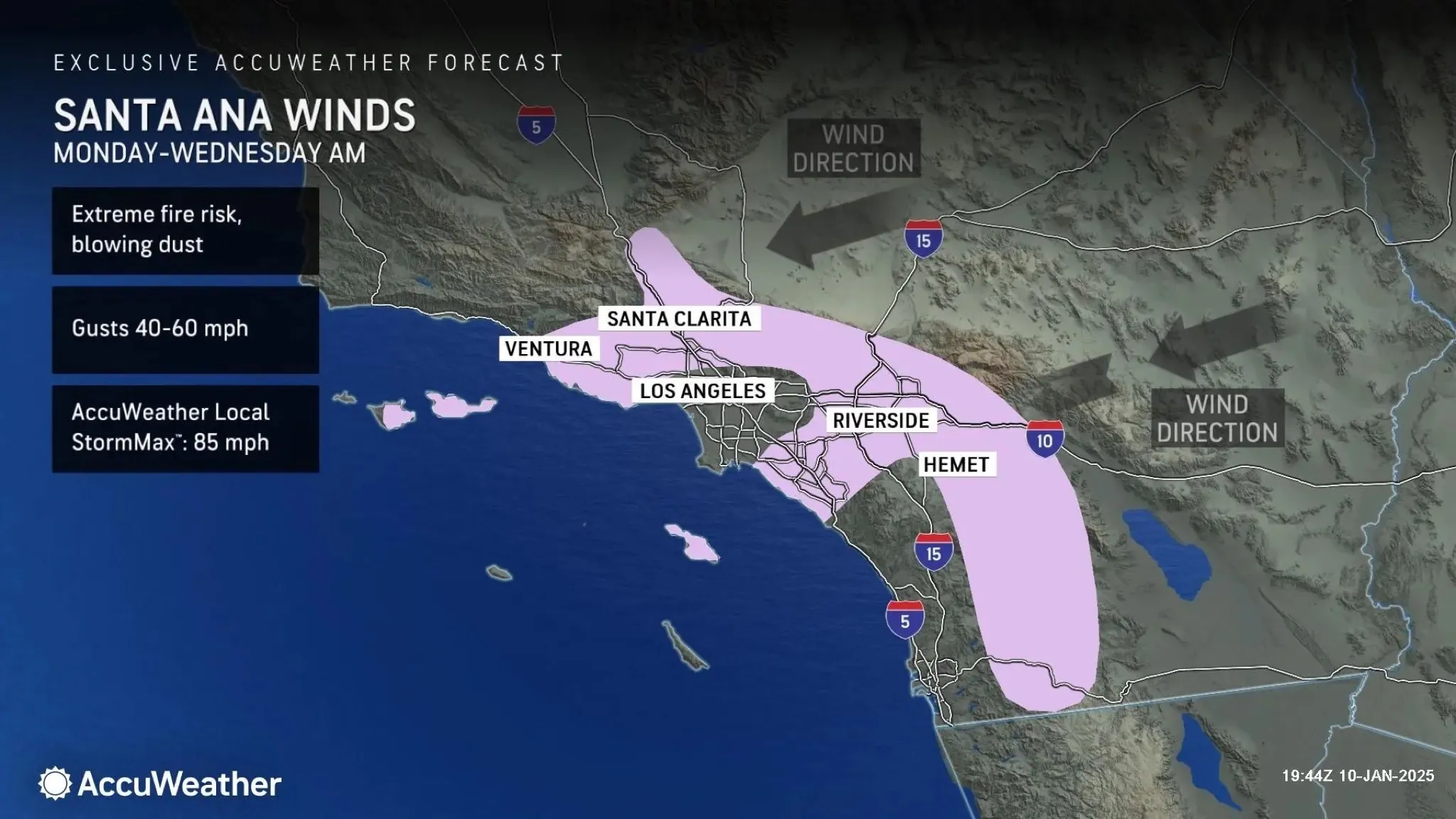
A bulletin from the federal agency predicts two high-wind events headed toward valley regions of L.A. and Ventura Counties: a windy weather pattern Saturday night into Sunday, followed by a stronger round of gusts Tuesday into Wednesday.
Unlike this week’s once-in-a-generation winds, which shifted the usual path of the Santa Ana Winds toward more populated areas and fueled the devastating Palisades and Eaton Fires, these upcoming winds will bring the strongest gusts to mountainous areas—but still pose a threat given the ongoing fires.
Between Saturday afternoon and Sunday morning, AccuWeather predicts wind gusts between 30 and 50mph through L.A.’s mountain ranges as well as the northern San Fernando Valley and coastal Ventura and Orange Counties. As a result, unhealthy air quality is expected to persist throughout the weekend.
After a brief lull, between Tuesday and Wednesday the NWS says wind speeds will increase to between 40 and 60mph, with isolated mountain gusts up to 80mph—which has “the potential for being as strong or stronger than all but the initial Santa Ana event last Tuesday,” though this time around, the winds are unlikely to produce the damaging “mountain wave” activity that saw gusts approaching triple digits.
During an Eaton Fire community meeting on Friday afternoon, officials acknowledged the forecasts, and Southern California Edison specifically warned that planned power shutoffs are possible—even in areas that have already lost and regained their power.
In the meantime, we’d suggest signing up for either the city or county’s emergency alert systems (and, you know, just hope that they don’t send out a false evacuation warning again). And anecdotally, Watch Duty has been an absolutely indispensable app for staying on top of evacuation zone updates and wildfire outbreaks during this week’s disasters.